Get Best Electronics Items
Lowest Price
$59

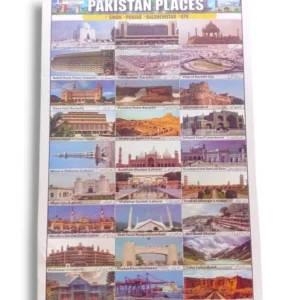
Pakistan Places Chart – Famous Landmarks & Tourist Sites Learning Chart
The Pakistan Places Chart showcases Pakistan’s most iconic landmarks and historical sites in a bright, easy-to-learn format. Perfect for classrooms, students, and general knowledge learning.
- Estimated Delivery : Up to 4 business days
- Free Shipping & Returns : On all orders over Rs 3000
Explore Pakistan Through a Beautiful Educational Chart
The Pakistan Places Chart is designed to help students and learners discover the beauty, heritage, and cultural richness of Pakistan. Featuring high-quality illustrations of the country’s most famous locations, this chart is perfect for geography classes, history lessons, and general knowledge enhancement. Its vibrant colors and clear labeling make learning interactive and enjoyable for all age groups.
Key Locations Highlighted
This chart includes carefully selected and widely recognized places from across Pakistan, such as:
-
Minar-e-Pakistan – Symbol of independence and national pride
-
Badshahi Mosque – A masterpiece of Mughal architecture
-
Khyber Pass – A historic trade route connecting South and Central Asia
-
Mazar-e-Quaid – Resting place of Quaid-e-Azam Muhammad Ali Jinnah
-
Faisal Mosque – An architectural icon of modern Pakistan
-
Shalimar Gardens – Reflecting the splendor of ancient Mughal design
-
Saif-ul-Malook Lake – A breathtaking natural wonder
-
K2 Mountain – The world’s second-highest peak
Each landmark is presented in an easy-to-understand visual format, helping students connect with Pakistan’s geography and history.
Why This Chart Is Useful
The Pakistan Places Chart is not just informative—it’s an excellent teaching aid. Teachers can use it for classroom discussions, quizzes, map-based exercises, and cultural lessons. Parents can display it at home to encourage children to learn about their country. Its durable printing ensures long-lasting use in schools, academies, and libraries.
Perfect For
-
School classrooms
-
Geography and social studies lessons
-
Home learning setups
-
Educational centers and libraries
-
Cultural learning activities
Quality & Material
Printed on premium-quality, fade-resistant paper, the chart ensures clear visibility even from a distance. Its laminated surface provides extra protection and a long shelf life.